Tag Archives: Stage 6

Beach Area Grande

We leave Cereixo till we get to the cemetery where there is a track on our right that will lead us to the road of the beach Lago. You shouldn´t rush when ascending and be very careful when walking the 500 meters left along the road: it is a very difficult stretch, without hard shoulders and we have to watch out for the cars as they don´t expect to see anyone walking along that road.

no images were found

After the 500 meters we leave the road by taking a path on the right that takes us to the eucalyptus forests to get to the beach Area Grande, which is already in the municipality of Muxía.

We don´t like walking along the asphalt at all, and we were looking forward to taking again our route. When we get to the beach, we have two options. The path that follows the track that is in the field parallel to the beach but, if the tide is low, we can walk across the beach

We don´t like walking along the asphalt at all, and we were looking forward to taking again our route. When we get to the beach, we have two options. The path that follows the track that is in the field parallel to the beach but, if the tide is low, we can walk across the beach

The sand is full of shells of clams and cockles. Some vessels also ended up their lives in this beach after sailing along this River Grande.

Cereixo

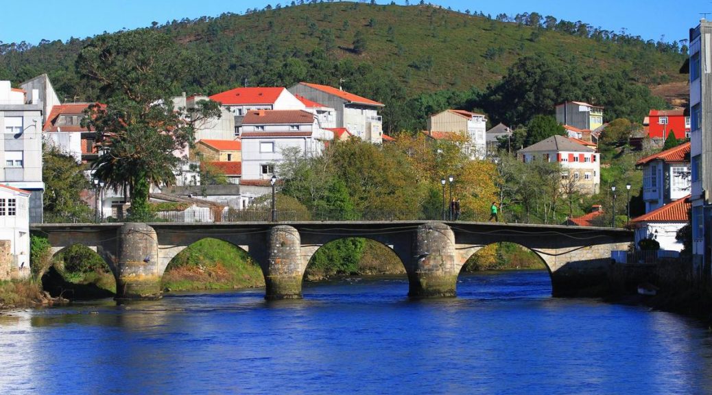
O Camiño dos Faros gets to Santiago de Cereixo, which belongs to the municipality of Vimianzo. It is a different landscape and strategic for the trade as it did already exist in the 10th century, but the lootings of the Vikings and Arabians all along the centuries 12th, 13th destroyed it. In order to re-found it, the king Alfonso XII provided it with the “carta puebla” and several privileges, visiting it in 1228 and making it stronger in front of the feudal lords. Its port was really important at that time.


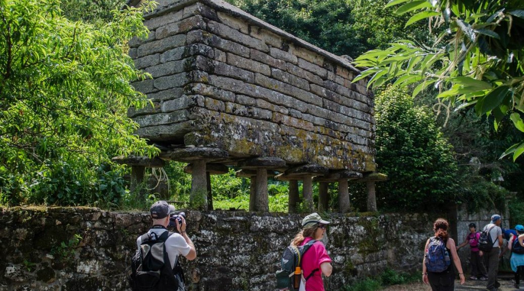
Before arriving, we are impressed when we see the silhouette of the 19-foot “hórreo”, one of the biggest in Galicia. It is placed in Vila Purificación, a baroque “pazo” that dates back to the 18th century where the taxes had to be paid and it also has a pigeon house.

We take the way that takes us to the riverbank by taking it among the first houses. The first thing that we see is an invention, the “Mill of the tides”, which was created centuries ago. It was built in 1679 by the family Moscosos and Altamira. This mill used not only the force of the river Riotorto but also the tides of the estuary to grind. Now, it is being used as a house whose main door is reached by using a wooden walkway (kind of small bridge) over the river.

From the mill, the path takes us to the riverside walk, with several information panels that will help us to get to know more the fauna and flora of this area. On the other side, we can see beautiful hanging houses. It seems as if the time has not gone by them. We use these nice shadows the river provides us with to stop to have something to drink and eat. We have done less than half of the stage, so we can`t stay there long if we want to arrive in Muxía.

By the stairs, we can get to Santiago de Cereixo´s church, that was built in the 12th century, keeping from that time the Romanesque ground plan and part of its walls.

The most attractive part is the tympanum of one of its doors, made in the 12th century. It is the oldest representation graved in stone of the scene that represents the moment when the Apostle Santiago was taken to Galicia on a boat with 7 disciples.

Next to the church, we see the robust Towers of Cereixo, built by the lords Calo and Carantoña in the 17th century, probably above a fortress that protected previously the mouth of the river from the continuous raids by the Vikings. When its role as a defensive building vanished, a new building was built to link both crenellated towers.  So, the ground floor was used as the place where the inhabitants paid their taxes, and the upper area as a dwelling.

On the main façade and on the lateral one, the shields represent most of the noble families, that had been in a particular moment, the owners of this “pazo”. At the beginning of the 20th century, the last owner descendant of these lineages had to sell it. Nowadays, the owner is an architect and visits are not allowed, but, as we can see from outside, it is in very good condition, so, well maintained.


In the middle of the square, there is an impressive oak whose age is unknown but what we actually know is that it is at least some centuries old, even older than the towers. The place under the tree top is also a good spot to rest as we deserve after the walk.

What do you think about this part of the route? We have left the coastline and got into the banks of the river Grande, a stretch that is full of life and history. We do believe it is worth walking it. Now, we have to stand up, as there is half of the stage left.


Ponte do Porto

This place is named after the bridge over the river Grande next to its mouth that dates back to the 13th century. This small port was important for its popular timber trade becoming the main point of this business all around the area long time ago.


We walk across the medieval bridge that is in the center of the village. On the other side we can see St. Peter´s Church, which keeps a very interesting collection of lacework. Apart from this, we can also see the houses made of stone overlooking at the river. It is actually worth stopping and seeing them.

Along the walk by the river till Cereixo we can see ducks and some other aquatic birds that find this mouth their best habitat.


Getting into the rural area

O Camiño dos Faros is a coastline route but, in some stretches, we are forced to walk along the inland. This is one of them, but it is worthwhile.  A stretch that is not longer than 2 kilometers from Tasaraño to Allo that takes us to a rural atmosphere that is still successfully facing all economic crises.

When we arrive in Tasaraño we have a fountain where we can refresh ourselves and get fill up again our bottles. Next to it, a horse chestnut and a stoned “hórreo” similar to the great deal of them we are going to see, as important to store the cereals for the livestock.

When we walk along Dor we can check again what happens all along this route. Another typical Galician village that keeps its past, a past that we should never forget.

After walking across the forest we arrive in Allo, where we will walk across the road in front of the school, which is already in Ponte de Porto.

Route of A Insua

The Mount of Insua divides the Bay Basa from the mouth of the River Grande. O Camiño dos Faros goes along the central dirty track of the coastline, bearing in mind that if there is low tide we can walk on the sand.

The route goes along the Eastern part of the Bay leading to Point Sandía where we see the beaches formed by the mouth of the River Grande, finishing in Ariño.


If we want to see some views of all the estuary and the village of Camariñas, we can ascend the 104 meters of “Alto de Insua”. It is not included in the route, and it is also a kilometer ascending by walking across pine groves that we will have to walk back to retake our Camiño dos Faros.

The first thing we see along the coast is the “Fountain of Agramar”, near the remains of the mine Amparo that was devoted to extract wolfram.

Walking along the Route Insua is kind of easy as it is through a path of pine groves that leads to the beach Ariña Blanca and Punta Sandría, which separates the bay from the mouth of the River Grande. It is at this point we can also enjoying seeing the shellfish activities when the tide is low.


After passing by Rego dos Coiros we arrive in Ariño. The beach of Ariño is another treasure of O Camiño dos Faros. This beach is surrounded by a pine grove with tables and stone seats which make of this place a perfect spot for the first stop.

Right in front of it, we can see the beach Area Blanca, which is already in the municipality of Muxía, but in order to get there we have to take a long way of at least 8 kilometers as we can´t go straightaway. We leave the beach Ariño by taking a track that takes us again to the road to get into the rural area of this area, leading to Ponte do Porto.

Bay of Basa

We keep on walking along pine groves along this V-shaped inlet that is the Bay of Basa which is extraordinarily rich in seafood. If the tide is low, we can walk along this stretch on the sand and see the riverbank vegetation as the shellfish activities carried out by the people from the area. They sow and harvest the fine clams, cockles, razor clams, which have become the activities their economy is broadly based on.

In summer months we can also see how they leave seaweeds drying, an activity that has a deep tradition in this area. It is the “argazo” (´gholfe´) a kind of species they sell to the factories to extract the carragenate, a substance used in food to gel some types of meat or increase the lifespan of some dairy products. It is also used in cosmetics, toothpaste, creams or even air-fresheners.  On our way, we can see several carpets made of seaweeds drying  all along the old roads with not traffic at all (the asphalt of the road makes the process be faster) or on any corner.


Around the shellfish farmers, the cormorants also find in this place a perfect spot to rest from their migrations.

We leave the bay and we walk along a small stretch along the road to avoid the “Rego do Trasteiro” and get to the village Xaviña. In the main straight you can see the “Bar-Parrillada Rojo” and, around 600 meters farther, a track on the right that takes us to the Route Insua.

Leaving Camariñas

Camariñas bids O Camiño dos Faros farewell. We get up early in the morning and we see the sunrise whereas we leave towards Muxía where this 6th stage will finish.

We take the way that surrounds the canning company Cerdeimar. With the arrival of the Catalan businessmen, from the 17th century, the industry of the salting process was mainly the one that gave boost to the Galician economy.
 

Around the middle of this century, the most important port in A Costa da Morte was Camariñas. More decked vessels than in any other place to trade the sardine with different ports from the Atlantic and Cantabrian coastline belonged to this port. They left the port loaded with sardines leading to the Basque Country and they came back loaded with iron they sold in the area.  In the Registry of the “Marqués de la Ensenada” in 1753, it is referred to the way of fishing the sardine in the village of the bobbin lacework.

With these new ways related to the salting process, the fish was salted in barrels to consume them in the winter months, mainly in the inland areas. “Salazones Cerdeiras” was founded in 1884 and after four generations is still operating.


The beach Area da Vila is one of the most visited by the inhabitants of Camariñas. In Saint John´s Eve the “Lumarea” takes place there, where the biggest bonfire of A Costa da Morte is lit.

At the end of the promenade bordering the beach we take a small path that takes us to Lingunde, another treasure of this estuary. From there, we start walking along the Bay Basa.