Tag Archives: Lighthouses

Lighthouse Finisterre (Cape Finisterre)

We have arrived in the Finis Terrae, the last point of our route which has taken us along this rough and beautiful area of the coast. The view in front of us is astonishing and surprises us as it had done with the Romans and the pilgrims that have arrived at this point all along the History. Down our feet, the immense Atlantic Ocean is sailed by thousand vessels that every day go across this maritime corridor.


There, near the Cape Finisterre, the wreck with the highest number of ships involved and more victims took place in Galicia. In 1596, 8 years after the disaster of the Invincible Armada and after several seasons of British lootings all along our coast, Felipe II ordered the Second Invincible Armada set sail. From Cádiz, Seville and Lisbon, some galleons and small vessels set sail forming a fleet of more than 100 ships, commanded by Martín Padilla.

On October 28th, in 1596 in front of the coast of Finisterre, suddenly they found themselves in the middle of a strong storm that caused the wreck of 25 vessels. The total disaster: 1706 crew members remained buried under the waters of this sea that is the one who imposes its law. The number of casualties (Santiago de SM (307), Nave Anunciada (243), Angel Gabriel de Paulo Veira (174), David de Pedro Frías (163) gives us the idea of the immense tragedy. The rest of the vessels appeared in the different ports all along the North till Biscay.

As it has happened with all the wreck along the years, these vessels have suffered from lots of plundering that are not punished or controlled. From 1987, the writings by Manuel Martín Bueno and Miguel Sanclaudio give more details about the condition of these archaeological remains.

The lighthouse was built in 1853 to mark this geographic point, really important for the navigation. The octagonal tower made of stone measures 17 meters and its torch, placed 138 meters above the sea level, reaches further than 30 nautical miles. At first, it worked with oil lamps that were replaced with filament lamps that emit a flash every 5 seconds.

As there used to be a constant fog in winter, a building was built next to it with a siren in 1889, the Vaca of Fisterra (“the cow of Fisterra”), to warn the sailors against the dangers. On the days where the coast was covered with the fog, it emits a low pitched sound that can be heard further than 20 miles.

The building “Semáforo” (“traffic light”) was built in 1879 to emit signs to the Navy. Nowadays, after being rehabilitated, it is a small and peculiar hotel at the “end of the land”.

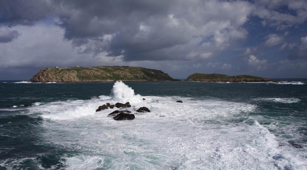
If we look towards the South, all the Ría of Corcubión, the islands of Lobeira and the imposing MountPindo complete the natural viewpoint.

And here, in the Finis Terrae of Decimo Junio el Bruto and the end of St. James´Way, is where O Camiño dos Faros finishes, the route that has taken us all along the Costa da Morte.

A Camiño dos Faros that goes along and across a lot of different landscapes, always looking at the sea and towards the West. Lighthouses, beaches, dunes, rivers, cliffs, estuaries with a great amount of birds, seas of granite, “castros”, dolmens, fishing villages, viewpoints overlooking the sea that breaks against the coast in many different ways, sunsets. In short, a unique hiking route that will take the hiker to a world of unique feelings that you can only enjoy along this Costa da Morte.

O Camiño dos Faros awaits you…


Lighthouse Touriñán

It is placed further west than Finisterre, although not as far as Cape of the Nave, which is the westernmost point of the Spanish peninsula. This huge prominent part of the coast is more than 2 kilometers long and it was perfectly marked when the lighthouse was built in1898 to guide the vessels during their voyage as these waters are really dangerous. We start this part by bordering the cape by taking a small path till we reach the lighthouse.

The original lighthouse was not supposed to be built, but as there were several wrecks at the end of the 10th century, it was inaugurated in 1898. They used the optic of the old lighthouse of Vilán. It was placed 50 meters above sea level and 8 meters high. It is next to the dwelling of the lighthouse keepers. Its light reached 10 miles, with a fixed white light produced by a lamp of paraffin. In 1918, this lamp was replaced with one of vapor of petrol, reaching 20 miles.

The new lighthouse, build in 1981, is a 11-meter tower made of concrete with a light that reaches 23 miles, flashing once or twice every 15 seconds. The westernmost point of this Camiño dos Faros is right there.

We sit down on the grass that is in front of the building. On its façade we can read the poem of an anonymous writer dedicated to God and written with a lot of patience. From the top of it, we can have a privileged view of the Atlantic Ocean.

On the right, down there, we can see the imposing Laxe dos Buxeirados, a “resting”, that gets into the sea and it is a real danger for the maritime navigation. As it happened in 1935, when both the German vessel Madelein Reigh crashed against the Galician fishing which ended up breaking into two, although all its crew members were rescued. It could be mentioned as if it were another wreck, however, if we take into account that 22 years later, in 1957 the Madeleine Reigh wrecked in the same place, we can thing that the fate of this ship was very capricious. Besides, near Touriñán, the German submarine destroyed a lot of allies during the First World War.

During one month a year, from the Equinox of the spring around March 22nd till April 25th, the “last” sun in Western Europe sets in Touriñán. The physician Jorge Mira explains perfectly this phenomenon in this video.

We say bye bye to Touriñán by taking a path that goes along the coast. There are 6 kilometers left and we will get to the beach Nemiña in a short period of time.

The Lighthouse of Vilán

At last we are in front of the majestic figure of the lighthouse Vilán, which goes out into the sea above a rock promontory 100 meters high, that is, without no doubt, a key point in O Camiño dos Faros. The surroundings are amazing. In front of it, the rock Vilán de Fora, is separated from the land by the canal O Bufardo, where the sea covers everything with a white foam.

The wind, present almost every day, shapes the rocks that end up having diverse forms. It is the perfect habitat for the sea birds. Some of them are endangered as the kittiwake or the guillemots, that are in these rocks as the last couples. Apart from these species, cormorants, shearwaters, common terns, or kingfisher find in this area their homeland.

In the CapeVilán, there used to be a steam lighthouse working since 1854, placed on an octagonal tower above a small elevation. Nowadays, some of its remains can be visited. This lighthouse, as it is not placed in the highest area, couldn´t avoid the visual obstacle of the cape and left some areas unprotected. They tried to solve the problem by exploiting some parts using dynamite but it was unsuccessful.

In 1885, the project of the construction of a new lighthouse was passed, and the tragedies related to the Serpent in 1890 and to the Tinacria in 1893 rushed its construction.  On January, 15th  in 1896, six years after the tragedy of the Serpent, the first electric lighthouse was inaugurated, which was considered to be a great improvement for the maritime navigation. The light was produced by means of an electric arch between two carbon electrodes. With a 25-meter octagonal tower its light reached 10 meters away, being one of the most powerful ones at that time. It was declared of “General Interest” in 1933. In 1962, the light optic was modified and it could reach 28 miles. A foghorn was also added.


The building that was used by the lighthouse keepers as their houses for them and their families was separated from the tower by a tunnel closed with stairs. Nowadays, we can visit the museum where we can see old optics and some other devices related to the history of the lighthouse, a center for the study of the wrecks, an exhibition room and the café.


If we have done the route from Arou, I am sure we are impressed with all the views, a Costa da Morte that is full of history, wrecks and legends that the own lighthouse Vilán, if he could tell us the stories, couldn´t even make them clear.

We set off towards Camariñas visiting the old lighthouse after descending a path full of gorse bushes and we have to border the fish farm.


There, at the sea level in Punta Esperillo, we can watch the real measures of Vilán from a different perspective. We say bye bye to it but making the promise to come back.


Lighthouse in Laxe

At the top of MountInsua we can  the Lighthouse of Laxe. It was built in 1920 and it is similar to that of O Roncudo, a simple cylinder covered with white tiles. Its situation, as that of the rest of the lighthouses, is privileged.

The vessel “Playa Arnela” sank in 1972, a vessel from Corme that was arriving to port when it hit against the rocks of Punta da Insua. Only two members of the crew survived. “This sea never forgives” as it is usually said by the inhabitants of this area.

Close to the lighthouse we can see the bronze sculpture “A Espera” (The Waiting), a tribute not only  to all the seamen but also to their women waiting for them to return.

On our right, the views of all the estuary of Corme-Laxe are amazing and if we have a look at our left the views of the open sea till Punta Boi are also awesome.

The Lighthouse O Roncudo

The name “Roncudo” has its origin because “ronco” in Spanish means hoarse that seems to imitate the noise the sea produces when it hits these cliffs. The simplicity of this lighthouse built in 1920, with its 11-meter height and the fact that it is surrounded by granite rocks and a wild landscape wraps the area with an aura of mystery. The breathtaking viewsof the estuary of Corme and Laxe completes the whole vision.

The strength the sea hits these rocks with and the characteristics of its water makes this area be an ideal place to hunt the famous gooseneck barnacle of O Roncudo, which is acknowledged as the most delicious one in Galicia and that is hunt by the brave fishermen that fight in these extreme conditions that have provoked some casualties so far as the 2 crosses we can see next to the Faro reminds us.

It is here in O Roncudo where lots of ships wrecked as they were not able to survive to the conditions of A Costa da Morte.

Lighthouse in Nariga

The surroundings of Punta Nariga is full with magic. A wind power plant was built to take advantage of the strong wind that dominates the area most of the year, which gives to the place a solitary aspect. When walking along it, we will see some rock formations with endless shapes.

When getting to the lighthouse, we see the construction by César Portela inaugurated in 1997 that imitates the shape of the bow of a ship getting into the sea. The figurehead is a sculpture by Manolo Coia and a perfect place to take a photo.

Being aware of the danger, we can walk along the rocks the lighthouse stands over. These rocks have different shapes because of the erosive effect the sea and the wind have on them.

It is the first big lighthouse we visit in our route and it is here where we understand the reason of the name of the route. Although the lighthouses are indsipensable elements along A Costa da Morte, it is from this point from where we can see a great part of what we have done so far in this first stage and part of the beginning of the second one. This possibility of seeing what we have walked and the route that is left will go with us along the rest of O Camiño dos Faros.

It is here in Punta Nariga where we will do the stop of grouping to face the last part of this stage that will lead us to the Beach Niñóns, with some difficulties. That´s why we do recommend doing it during the day, never at night.

Sisargas Islands

The Sisargas Islands are a small archipelago uninhabited placed 1 mile off the Cape of Saint Adrián in Malpica. This archipelago is formed by the islands “Grande”, “Chica” and “Malante” together with some islets. They were inhabited in the past as the presence of the Chapel Santa Mariña proves. This chapel that was destroyed by the pirates in their endless raids all along the 10the century.

This nature reserve is rich in plant and animal life. Loads of endangered birds nest in these islands and some other ones just use them to rest in their long-distance migrations. Species such as the herring gull, the kittiwake, and the seagull known as the “dark” seagull. They find in the cliffs that are in the northern part of the island the perfect habitat.

If we have the chance of getting close to the island and walk along it, we shouldn´t miss it. There is no company that can take us, so the only way is to find a ship from Malpica that take us there.

We land in a small natural port. We can take a dip in the only beach the island has and start a walk that will take us to the lighthouse admiring an amazing view of Malpica and Saint Adrián. The seagulls and the herring gulls are the real owners of these islands and they will come with us while we stay in the island. They will protect their eggs and their chicks.

We reach the lighthouse. It was built in 1919, and it has a mute witness and guide for those sailing by for a long period of time. The lighthouse keeper used to stay there for 15 days alone in the islands till he was replaced by another one. The cliffs near the lighthouse reach 100 meters high. The croaking of the birds and the noise the sea makes are mixed in this view of the sea causing a feeling of vertigo that we will never forget.

We leave the cliffs to head to the forest that covers a huge part of the highest area of the GrandeIsland. This small forest surprises us because of the amount of leaves of the pines. Curiously, the absence of human beings has allowed that the treetops reach our heads.

We descend again till the pier where there is a ship waiting for us that will take us to land after spending some hours that are unforgettable.