Tag Archives: Stage 5

The Lacework of Camariñas

All along this area, people do lacework. If there is a typical image of this area is the one where we can see a groupe of women doing bobbin lacework (“palillear” is the term used). These women with loads of patience make this beautiful lace that is sold worldwide. The main characteristic of this lace is that is handmade by turning the bobbins with the threads right and left above a cardboard stencil of the design.

This technique that comes from the trading with the ports of Flanders in the 16th century, has been developing along this area reaching a level of perfection in the art of bobbin lacework. Tablecloths, bed linens, quilts, cloths, wedding dresses are made by these female artisans that, bobbin after bobbin, pinhead after pinhead, keep this artistic expression alive.

As History says, in the 17th century, some nobles came back from the war in Flanders married with women from that region who brought new techniques. At that time, the lacework was already known and appreciated by the upper classes, reaching its highest splendor in the 18th century, thanks to the refinement of the technique and the creation of the first “palilladas”, a costume that still remains nowadays, whose main purpose is to gather these women in front of their houses to carry out their work.

At the end of the 19th century and beginning of the 20th loads of this lacework was exported from Camariñas to America. However, these exports were interrupted because of the colonial crisis and the world wars.

When the conflicts reached an end and after being once again organized, this activity flourished again and it still remains nowadays. With more than 2,000 women (¨”palilleiras”), the bobbin lacework made in Camariñas is really popular in fashion, in lingerie collections and in decoration.

During the “Mostra do Encaixe” (an exhibition of this lacework), which has taken placed yearly since 1991, thousands of people go to Camariñas to see these women work, but not only the local ones but also women from other countries where this work is carried out.

Invalid Displayed Gallery

Port of Camariñas

It is one of the most important in A Costa Da Morte and it is the point around which the life of this village is developed.

On the façade of one of the houses in this port, we can see the air pressure sensor that the British Admiralty gave the village as a present for their help when the wreck of the Serpent had taken place. A great and modern device at that time and an expression of gratitude to those people that, all along the centuries, had risked their lives for those unknown people that, sailing through this sea, they faced the worst way to die. 

Here, in the port of Camariñas, we finished the route singing this 5th stage of O Camiño dos Faros that started in Arou and that has brought about a great deal of feelings.

Ao pasar por Camariñas
por Camariñas, cantando
Ao pasar por Camariñas
por Camariñas, cantando
as nenas de Camariñas
quedan no río lavando
as nenas de Camariñas
quedan no río lavando

Camariñas, Camariñas
xa me vas camariñando
Camariñas, Camariñas
xa me vas camariñando
por unha de Camariñas
vivo no mundo penando

Castle of Soberano

In the Middle Age, the Normand pirates used to visit our estuaries. All along the centuries, 16th, 17th and 18th this part of the Costa da Morte suffered from a great deal of pirate raids. As a consequence, the authorities created a plan reinforcing the coast with the building of castles as this one in Camariñas together with the ones in Fisterra, Cee and Corcubión.

castelo soberano

The castle of Soberano was built in 1740, during the reign of Carlos III, forming a military protection that defended all the entrance of the estuary and it had 17 “troneras” (kind of open part of the walls of the military walls that defend an area”. Everything was defended by a walled enclosure with a bastion, two halves of bastion and a ditch in between. Inside, there was a storage shed that was used as a dwelling and storage of powder kegs. We have to sum up another that was built in Muxía in 1801, making any raid through the estuary kind of hard.

In the 40s, this walled enclosure used to defend the area, had stopped working as such. The necessity and the ignorance made people take the stones and use them to build a new port. Even, some of the canyons were placed as mooring for the ships. Nowadays, the foundation and part of the external wall are preserved, which are actually run by a private businessman. The final use of this cultural heritage is unclear as it also depends on the Institution in charge of patrimony.

O Camiño dos Faros goes around all this walled enclosure, and we can stop after each step to enjoy the remains of this fortress dated back from the 18th century, most of them hidden by the undergrowth.

At the end of this route, we can watch the port of Camariñas form a viewpoint.

The Chapel of A Virxe do Monte

It was built in the 18th century over the ruins of an older chapel. As it used to happen in many villages, the fishermen’s wives used to go up the roofs to change the position of the tiles, believing that by doing so they will change the direction of the wind and their husbands could come back home soon. Near the chapel, a “romería” (kind of popular celebration) was celebrated at Easter.

From this beautiful and isolated spot we can enjoy a big panoramic view of all the estuary of Camariñas. 

We are privileged, not only are we in front of an amazing view of A Costa da Morte but we also see the next stages of O Camiño dos Faros that will take us through Muxía. In front of us, the silhouette of “la novia del viento” (the wind´s girlfriend as it is Muxía known) with its Punta A Barca are waiting for us.

From there, in this Camiño dos Faros, which is always heading towards the West, we can enjoy another amazing sunset typical along this coast. A treasure for those who are able to enjoy it.

But we can stay there for long. We go back to the football ground and we take again the path we had left that will take us to the beach of the Lake leading to Camariñas.

The Sea in Vilán

From the fish farm, the 7-km coastal path starts. It will take us till the port in Camariñas in 2 hours. Along the easy to walk route we can enjoy the privileged views of the estuary.

In the area of Coenda, when the sea is hitting hard, the coast provides us with amazing images. Huge waves hitting against the rocks making a strong noise full of white foam. 

Right from the football ground, we take a route on the right and we ascend the MountFarelo to get to the chapel of the “Virxe do Monte”.

The Lighthouse of Vilán

At last we are in front of the majestic figure of the lighthouse Vilán, which goes out into the sea above a rock promontory 100 meters high, that is, without no doubt, a key point in O Camiño dos Faros. The surroundings are amazing. In front of it, the rock Vilán de Fora, is separated from the land by the canal O Bufardo, where the sea covers everything with a white foam.

The wind, present almost every day, shapes the rocks that end up having diverse forms. It is the perfect habitat for the sea birds. Some of them are endangered as the kittiwake or the guillemots, that are in these rocks as the last couples. Apart from these species, cormorants, shearwaters, common terns, or kingfisher find in this area their homeland.

In the CapeVilán, there used to be a steam lighthouse working since 1854, placed on an octagonal tower above a small elevation. Nowadays, some of its remains can be visited. This lighthouse, as it is not placed in the highest area, couldn´t avoid the visual obstacle of the cape and left some areas unprotected. They tried to solve the problem by exploiting some parts using dynamite but it was unsuccessful.

In 1885, the project of the construction of a new lighthouse was passed, and the tragedies related to the Serpent in 1890 and to the Tinacria in 1893 rushed its construction.  On January, 15th  in 1896, six years after the tragedy of the Serpent, the first electric lighthouse was inaugurated, which was considered to be a great improvement for the maritime navigation. The light was produced by means of an electric arch between two carbon electrodes. With a 25-meter octagonal tower its light reached 10 meters away, being one of the most powerful ones at that time. It was declared of “General Interest” in 1933. In 1962, the light optic was modified and it could reach 28 miles. A foghorn was also added.


The building that was used by the lighthouse keepers as their houses for them and their families was separated from the tower by a tunnel closed with stairs. Nowadays, we can visit the museum where we can see old optics and some other devices related to the history of the lighthouse, a center for the study of the wrecks, an exhibition room and the café.


If we have done the route from Arou, I am sure we are impressed with all the views, a Costa da Morte that is full of history, wrecks and legends that the own lighthouse Vilán, if he could tell us the stories, couldn´t even make them clear.

We set off towards Camariñas visiting the old lighthouse after descending a path full of gorse bushes and we have to border the fish farm.


There, at the sea level in Punta Esperillo, we can watch the real measures of Vilán from a different perspective. We say bye bye to it but making the promise to come back.


Beaches of Reira

The beaches or Feira are the four beaches placed between the beach Trece and the CapeVilán. They are beaches with fine sand, very windy and with huge waves, surrounded by a charming almost unspoiled landscape.

We walk through the beach Reira to get to Punta Forcados, where we can see “A Pedra do Oso”. Someone liked the rock and he or she took it with him or her in 2002. Actually, nobody knew anything about it for a few days. It ended up appearing in a construction area as some building workers had been asked to bring some stones from Camariñas. As it was easy to be found, they loaded it with a crane and let´s go! This is a kind of stories that can happen in A Costa da Morte which makes us think how vulnerable our cultural heritage is.

Close to the beach, we can see also the ethnographic collection of Foxo dos Lobos, an old device the inhabitants from the area used to catch the wolves, whose presence in this area is widely spread. 

Close to the beach, we can see also the ethnographic collection of Foxo dos Lobos, an old device the inhabitants from the area used to catch the wolves, whose presence in this area is widely spread.

We will walk through the beaches Balea and Pedrosa before going up the mountainside of the mountPedrosa till we take again the dirty track that will lead us to Vilán.


All along this stretch, we can see the lighthouse Vilán. We will reach it as soon as we walk across the windmill of the “Alto da Vela”


Cemetery of the English

Here, on the left side of the beach Trece, in Cape Tosto, in the “resting” known as the Punta Boi three wrecks took place at the end of the century 19th that left a permanent mark in the History and name of A Costa da Morte: the Iris Hull (1883), the Serpent (1890) and the Trinacria (1893).

The Irish Hull was an English 1433-ton steamboat that had left Cardiff heading India via Gibraltar, manned by 38 men. At 04:00 a.m., on November 5th, 1883, facing a hard storm coming from the Northwest crashes with the so-called “Baixos de Antón” (“baixos” are a group of hidden rocks on the coast) in Punta Boi. The vessel gets destroyed. The fight between life and death was just starting, lasting a long and harrowing day.

A witness told as it happened: “Yesterday, it was around 8 o´clock in the morning, when we started hearing that a steamboat had wrecked near the CapeVillano and its crew members were asking for help from the masts. Loads of people run to the place where the wreck was taking place, encouraged by the feeling of humanity. We were looking forward to saving those unfortunate men that were fighting against the death at half league distance North in a place known as the Point Boi. The image we saw when we arrived was devastating: the vessel was completely under the water and partially destroyed. 2 out of the 3 masts were still in good condition and in the riggings, tied up to the masts, 9 men that as soon as they saw some people onshore who were ready to help them, doubled their cries for help. They were close to the land that, on days overwhelmed by calm, people from the vessels can have conversations with those in land, leaving all these rocks dry when the tide is low.

Such an image, hit the spirits, increasing the pain as the chances to get them saved were small. There were huge mountains of water that covered them from time to time. The wind was blowing hard from the South and the breakers that reached further than 2 miles, made almost impossible reach the vessel by using small boats and save these unfortunate people

During the whole day, the rescue actions were unsuccessful. Two of them tried to reach the onshore by swimming but they ended up disappearing under the waves. Luckily, there was a survivor called George Chirgwin that was pushed by the sea to the land and he appeared full of blood on the beach Reira.

A great deal of criticism was published on the papers regarding the isolation this village was involved in. “This devastating event filled the inhabitants of this village with a feeling of sorrow. If you publish the piece of news you will help humanity, highlighting the fact that the authorities in charge of the Navy have ignored this area for long as there aren´t any rescue and survival equipments other countries are provided with on a coast that is broadly  known as being really dangerous where lots of wrecks occur. Without no doubt, if yesterday we could have thrown a rope to the men who were on the masts, as it was that close to the land, there would not have died. But as we can see our authorities think about the risks when the tragedy has already occurred and whereas we are witness of a tragedy as this one the only think we can do is just to stay there just watch without doing anything

The corpse were buried next to the Point Boi, a kind of deadly point where seven years later the wreck which would be the one that would have more impact along History happened.

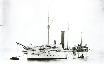
The ship Serpent was a vessel that belonged to the British crown. It was 75 meters long with 175 crew members. It had left Plymouth on November, 8th in 1890 in the middle of a huge storm coming from the Southwest, commanded by the highly experienced Harry L. Ross. The gunboat Lapwing was sailing with them and it was heading Sierra Leona via Madeira.

HMS_Serpent

At 11:00 p.m., on November 10th crashed against the rocks in the Point Boi. It got tucked among the rocks but it successfully remained on the surface for longer than an hour, throwing some ropes that broke when hitting the rocks. They tried to raise the boats but the waves made them crash against the rocks. Every time they tried to leave the ship was unsuccessful and the scenes of chaos and panic covered the night.

The rough sea took these crew members´ lives away. Only 3 of them could miraculously survive as they were literally spat by the sea to the beach Trece. Two of them were wandering around up to the mount till, in the following morning, they were found by a farmer in Pescadoira.

Along the following days, the sea was leaving the corpses along the coast, most of them were the corpses of young men. The inhabitants of Xaviña and Camariñas helped to bury them in a place that had been already devoted to bury the crew members of the Iris Hull: a small cemetery, known, currently, as the Cemetery of the English.

After this tragedy, the priest of Xaviña and the inhabitants of this area were awarded by the British Admiralty. A shotgun for the priest, a golden watch for the mayor and an air pressure sensor for the village of Camariñas. The sensor can be seen in one of the houses in the port.

Throughout the years, every time a ship sailed this area its crew members used to fire a salute throwing a wreath of flowers to the sea in memory of the victims. This has been the wreck that has had a bigger impact all along History.

As a reaction to this tragedy, some changes were made to improve the conditions of sailing along this coast. One of them was the construction of the Lighthouse Vilán, whose construction was rushed after these three tragedies.

It was early in the morning from February 6th to 7th, in 1893 when a storm was hitting the coast of Vilán. The British vessel Trinacria had left Glasgow heading Gibraltar, Genova and Livorno, with a load of iron, brick, coal and wax. 33 crew members and 4 passengers, including a 15-year old girl were travelling there.

When they were about to dock in Vilán, its captain Mr. Muny mustn´t have realized that they were approaching land in a dangerous way. At 6 o´clock in the morning, it crashed against the lowest area of Lucín. The scenes of chaos and panic started happening again on this coast and another ship was victim of this Point Boi that never “forgives” an error. Surprisingly 7 crew members were brought back to the beach Trece watching, at sunset, how there was nothing left from the Trinacria. They were taken to Camariñas where they were assisted till two days later, they set off to Corcubión.

Little by little, the sea was “spitting” the corpses that ended up being buried in areas nearby. After a few days, loads of wood, ropes, wax, pieces of clothing and corpses started appearing among the rocks. Although they tried hard to identify them, they ended up throwing petrol over them and burn them. Since then, this place that is very close to the Point Boi is called as “A furna dos difuntos” (The cave of the deceased)

This tragedy was the straw that broke the camel´s back. The tragedy of the Serpent had taken place 3 years before, and in that period several tragedies had occurred in the same point. The British sailors called this area the coast of death and the British authorities put some pressure on the Spanish ones. The Lighhouse Vilán is opened in 1896, being the first electrical lighthouse guiding the sailors in this difficult sea to sail Costa da Morte.

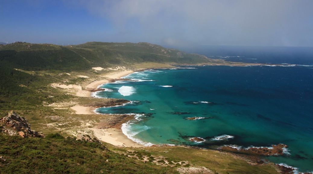
We stop to visit the cemetery, and looking towards the sea of Punta Boi, we think about how beautiful O Camiño dos Faros is for some people and how tragic is for some other ones.

From this point, we watch for first time the mythical Cape Vilán, a key point in this Camiño dos Faros. It will take us longer than two hours and a half to reach it.


Beach Trece

Descending the dune MountBranco and reaching the beach Trece on a sunny winter day surrounded by the sea with big swells is one of the best experiences A Costa da Morte can provide you with.


Being of great natural beauty, and as the Atlantic ocean is hitting it constantly it has a desert-like aspect as nobody stops by this place, with protected flora species as the “caramiña” (corema album), which can grow in extremely severe weather conditions. The village Camariñas was named after it. This flower could be seen along the coast in the early times, however, nowadays it is endangered.

We go through the beach which is formed by small coves divided by “restingas” of rocks that go out into the sea.


A mix of sea, wind, sand and rocks that create everywhere beautiful spots to stop and take photos.

The beach Trece is a unspoiled coastal spot to enjoy and preserve. Xorxa and Tolo are aware of this special experience and they are enjoying as we are doing.

We walk along the coves one after the other one, getting the most of each one with no rush, till we reach the end of the beach, where we make a provisioning stop in the small forest of the trasnos, where the wind has also given shape to the cups of the trees, transforming it into a welcoming and cozy shelter. 
 

Dune of Mount Branco

From the port of Santa Mariña we go up the dune that goes up along MountVeo till it reaches a 150-meter height, the biggest in the Peninsula. We will go through it till we reach 80 meters. Remember not to leave the sandy path in order to avoid stepping on the dune vegetation.

When we reach the top, we have reached the halfway point of O Camiño dos Faros. Apart from this particular feeling of reaching this point, for me, the trasno who is telling you this story, believes that the summit of this dune is one of the most amazing points in this route. Just think how the wind “works” to bring the sand from the beach up to create this mount. 

From this point, the panoramic view of the beach Trece and the Point Boi with the Cemetery of the English will remain engraved in our minds. It is an unspoiled landscape, far away from the madding crowd and with the sound the sea makes hitting constantly this Sea Trece.
 

The feeling is unique, this is the essence of O Camiño dos Faros!

no images were found