The last stage of O Camiño dos Faros starts at this point, on the beach Nemiña, one day with low tide and enjoying another amazing sunrise. We can admire, from that point, what is left till we reach the mythical Finis Terrae: from the left to the right the beaches Rostro, Arnela and the Cape of the Nave, which is the last point before reaching the CapeFisterra.
One of the best feelings all along this adventure is when we walk across the beaches when the tide is low, which mixed with the light of that morning, if forms a huge mirror on along the beach.
At the end of the beach, we see the mouth of the estuary of Lares, which makes us choose a longer route of at least 3 kilometers along the bridge Valsilveiro and Lires. We wouldn´t need to walk longer if we walked across the ría, but it is possible only two hours when the tide is low in summer time. When it rains, the channel that is formed makes it impoosible.
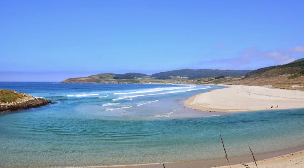
It is place in a privileged environment of the Ría de Lires, the beach Nemiña is the last part of the 7th stage, that has been, because of being a really rugged area, the hardest and demanding.
The beach of Nemiña is placed to the South of the CapeTouriñán. It is perfect for surfing, fishing and with the best big European seabass in the area. The mouth of the estuary of Lires also gets into this beach forming an amazing landscape.
Among the people of the group, we could perceive different feelings. On the one hand, we were really happy as there was only one stage left to reach the CapeFisterra, as many travelers had done along a lot of centuries, but we were going to reach it by taking the wildest route: O Camiño dos Faros. But, on the other hand we could feel a bit of sadness among us as the end of this adventure was closer, and adventure that we didn´t want to finish at all.
Along the route we see A Insúa do Castelo, a small island just few meter off the coast where there are some archaeological remains. Further, we can see the cliffs of Nemiña and for first time, the far Cape of the Nave, the last prominent part of the mythical Finisterre.
This route is much fun and with amazing views till we reach the small port in the Coído de Touriñán, that we walk across towards the viewpoint.
From Touriñán to Lires any place is great to see the sunset. One of them is, of course, the viewpoint that is on the road. It can be one of your choices.
From there, a paved road with not too much traffic is perfect for us to rest after the demanding route we have done so far. O Camiño dos Faros goes towards the West, that´s why at the end of each stage we can admire a different sunset.
It is watching this scope of colors and talking about the stage how we pass by the village of Talón looking for the last stage.
It is placed further west than Finisterre, although not as far as Cape of the Nave, which is the westernmost point of the Spanish peninsula. This huge prominent part of the coast is more than 2 kilometers long and it was perfectly marked when the lighthouse was built in1898 to guide the vessels during their voyage as these waters are really dangerous. We start this part by bordering the cape by taking a small path till we reach the lighthouse.
The original lighthouse was not supposed to be built, but as there were several wrecks at the end of the 10th century, it was inaugurated in 1898. They used the optic of the old lighthouse of Vilán. It was placed 50 meters above sea level and 8 meters high. It is next to the dwelling of the lighthouse keepers. Its light reached 10 miles, with a fixed white light produced by a lamp of paraffin. In 1918, this lamp was replaced with one of vapor of petrol, reaching 20 miles.
The new lighthouse, build in 1981, is a 11-meter tower made of concrete with a light that reaches 23 miles, flashing once or twice every 15 seconds. The westernmost point of this Camiño dos Faros is right there.
We sit down on the grass that is in front of the building. On its façade we can read the poem of an anonymous writer dedicated to God and written with a lot of patience. From the top of it, we can have a privileged view of the Atlantic Ocean.
On the right, down there, we can see the imposing Laxe dos Buxeirados, a “resting”, that gets into the sea and it is a real danger for the maritime navigation. As it happened in 1935, when both the German vessel Madelein Reigh crashed against the Galician fishing which ended up breaking into two, although all its crew members were rescued. It could be mentioned as if it were another wreck, however, if we take into account that 22 years later, in 1957 the Madeleine Reigh wrecked in the same place, we can thing that the fate of this ship was very capricious. Besides, near Touriñán, the German submarine destroyed a lot of allies during the First World War.
During one month a year, from the Equinox of the spring around March 22nd till April 25th, the “last” sun in Western Europe sets in Touriñán. The physician Jorge Mira explains perfectly this phenomenon in this video.
We say bye bye to Touriñán by taking a path that goes along the coast. There are 6 kilometers left and we will get to the beach Nemiña in a short period of time.
We leave Moreira and walk towards the lighthouse by taking a dirty track, leaving the village of Touriñán on our left hand.
Touriñán is another typical village, with loads of “hórreos” and its inhabitants are used to surviving the hard winters. As usual, after every step, there is a wonder provided by nature that surprises us along the route.
In this area, there used to be wild horses but, they have not been seen anywhere. Neither here nor in a different route they have appeared. On this side of the lighthouse, the sea hits hard against the rocks of the Cape.
We can walk along the eastern part of CapeTouriñán by taking a small path on our right till we get to the lighthouse.
Before going on, we are going to small stop in Moreira to rest for a bit in this beautiful cove with “bolos” (relatively big-ball shaped stones) and sand. We have already walked the most demanding stretch of the route, 10 kilometers which seemed to belong to a mountain range than a route along the coastline.
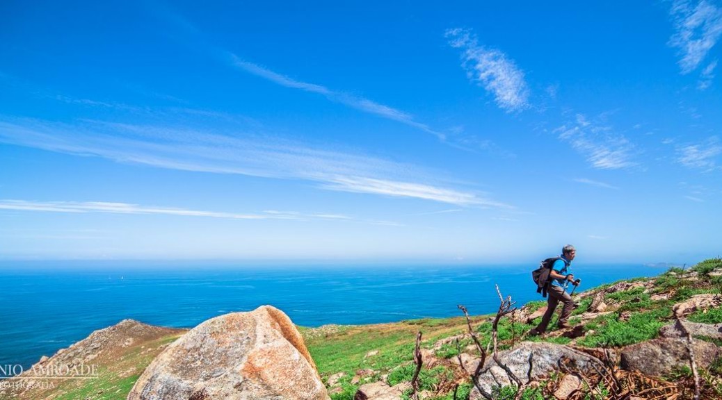
From this point, we see how inaccessible is the Ribeira of Viseu. These huge cliffs do not let us walk closer the coast. Consequently, we have to go on walking bordering their summits. It is a pity, of course but on the other hand, as human beings don´t have access, they will never be spoiled.
The beach of Moreira is an oasis in this sea of rocks. The seagulls perfectly know so, and they take a rest as we do before going on towards the next point in our way: Touriñán.
If the stage till that point had been of loads of ascents, it is at this moment when we start the huge descent of this stage. From the 269 meters of Mount Pedrouzo we have to descend till the sea level, to reach the beach Moreira.
We take a path along the Ribeira of Viseu to get the huge descent of O Camiño dos Faros: the descent to Moreira. Our route is full of feelings and this is great! While we try not to fall down, which is very common at this point, we stop from time to time to admire, a bird’s eye view, a panoramic that you only “see” if you are a Trasno.
On the foreground we see the silhouette of the Lighthouse Touriñán, another outstanding site of this Camiño dos Faros. It will take us longer than two hours to get to it.
It seems incredible that in spite of the fact that we walk all this route along the coast we have to ascend up to this point, but the charm of this Camiño dos Faros may be behind these moments. In order to reach the summit of the 269-meter MountPedrouzo, we will have to ascend a hill for along 2 kilometers with a gradient of 13%.
From the Rego do Cuño, where we stop to have lunch, the route gets inland, towards a forest. And be careful at this point! If you go on along the cliffs it is impossible to reach anywhere and very dangerous.
Across these forests, we start ascending up MountPedrouzo, which is not very demanding, but as we have walked along so far, one feels already exhausted.
The summit of the Pedrouzo is a place we can considered to be very “trasno”, and the stones that are on that peak are the best place to gather and wait for those who are walking a bit behind. We stop for a short rest and enjoy the panoramic views of the CapeTouriñán getting into the sea.
As the rest of the stage, there is only one thing we perceive: the silence. The sounds the sea makes don´t reach this point, it is a place where people usually don´t go and just a few animals have been the witness of our walk all along the whole day. We are overwhelmed by a feeling of calm that only O Camiño dos Faros can provide you with.
The Coído of Cuño is the SPA of the Trasnos, a present in this stage after the great effort we have made. We take off the back bags, we prepare the things to eat and drink and it is high time to take a rest.
This Coído of Cuño is full of rolling stones of all sizes, and it has a great geologic interest. It may have its origin in quaternary deposits, although some authors believe that it is on a marine terrace. With the Prestige, all these rocks got covered by a black coat of fuel oil impossible to get rid of. There are still some remains of it that we can see. Not only in this coído but also in Moreira, scientists tested different methods of bioremediation, which is a process that makes use of microorganisms that get rid of this contamination. We don´t know if during the quarternary there was jam, but it is time for us to eat something. We take the knife, slice the loaf, put some jam, cheese and tomato..and let´s eat it. As you can see, we don´t prepare anything too complicated but we do eat.
As we are eating our sandwich and our feet rest with the water of the small waterfalls formed by this small stream of Cuño, we think once again how lucky we are. Perfect places are there outside to enjoy this adventure 100%.
However, the rest can’t last all day long, and after a while resting, we have to ascend from Cuño up to the 269 meters of Mount Pedrouzo.
From Cachelmo we descend along a very demanding path that will take us to a small track of the small beach Arnela which is in an unspoiled area.
It is a beach with a difficult access and hidden by the land and the sea, which has been sometimes used by the drug-traffickers to unload the illegal substance. When we reach the end of this track we ascend along the mount till Punta Buitra.
Punta Buitra is another prominent part in this rugged coast of Muxía, which makes you somehow walk over the ocean. We walk across the track with beautiful views of the sea that hits against the cliffs of the mountCachelmo and the beach Arnela.
When we reach the end, we get surprised this time by the cliffs of Cuño. The mount seems to fall in a kind of abrupt way, by forming some puntas the sea hits against continuously, fill them with foam. It is really sad that there isn´t a small path that goes along this side of Point Buitra till Cuño. We know that it is not an easy land to walk, but it would be an amazing route.
In order to reach Cuño, O Camiño dos Faros, ascends directly to the summit of Mount Buitra. This stretch of the stage is like this… every stop we make seemingly over the sea of Muxía worths the demanding moments when ascending.
From the dirty track, near the antenna, we start the route that will take us to the Coído de Cuño, where we are going to make a long stop that we actually deserve.