Tag Archives: Stage 6

Walk of Memory: the disaster of Prestige

At 15:15 on November 13th in 2002, the Bahamas registered vessel Prestige, a single-hull oil tanker, launched an S.O.S up to 20 miles (50 kilometers) off the coast of Finisterre. The nightmare started at that moment.

The vessel, built in Japan 26 years ago, a leak probably caused by a blow from the sea that knocked against two empty starboard side tanks, which made it heel 45 grades. The age of the vessel must have been the main reason of the leak. Surprisingly, it has appeared on the right side that had been repaired a few months ago at a Chinese shipyard.

One hour after the warning sign, the twenty four crew members are rescued by two helicopters. Only three people remained on the vessel: the captain, the first officer (second-in -command) and the chief engineer officer. At 5 o´clock in the afternoon, the first liters of fuel oil, started contaminating the Atlantic.  In order to avoid the spilling of more oil on the ocean, the tanks on the left side are filled up with water to try to keep the vessel in balance. Consequently, the vessel recovers its horizontal alignment, but, according to the technicians, it provokes a “severe overload”. Maritime Authority states that with this overload the vessel is not allowed to enter the Port of A Coruña, so, it is forced to stay in the high seas. From this moment on, a series of errors were committed. It´s known that the draught after the vessel recovered its balance after filling up the tanks (14,3 meters) was enough to enter the port (18 meters) and its tanks could have been emptied to avoid the oil spill.

From then on, the vessel owner, the Government and the salvage enterprises that had been hired start arguing to decide about the destination of the vessel with its 77, 000 tons of fuel oil. Only the tug boat Ría de Vigo is in the area where the tragedy is taking place. Other 3 tub boats head to the area, one of which has to return to port as it gets damage. Very late at night, the Dutch enterprise Smit Tak signs a contract with the ship owner and it is in charge of the rescue. At this moment, the vessel has lost 6,000 tons of fuel oil that are spread as a huge stain 10,000 meters long and 300 wide. The Governments assures that the vessel will be taken off the coast 120 miles immediately. The tragedy has just started.

NUNCA MAIS!

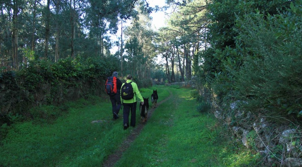
Thousands of tons of thick fuel caused an ecological disaster contaminating all our Camiño dos Faros. However, this tragedy brought about a tide of solidarity with the Galician people: thousands of people came from the most different places came to help to clean the coast line. Thanks a lot (“graciñas” in Galician) to all the volunteers, we, the Trasnos will be always thankful for all your help”.

Those days were really difficult, very difficult for all of us. It is then when you realize how vulnerable we are and that we live in a society with different priorities than that of life itself. The last part of this stage takes us to this stretch of the coast till the beach of O Coído, which is considered to be the kilometer 0 of that tragedy.

no images were found

The monument of A Ferida (“the wound”) as the tribute to the volunteers is the first we see when leaving A Barca. It is a 400-ton monolith of 11 meters high carved in granite whose structure is divided in two.  This division gives shape to a breach that represents a bleeding wound. It was created by the sculptor from Burgos, Alberto Bañuelos-Fournier, paid by a insurance company that paid 120, 000 for its transport expenses, the rent of the cranes and the stone.

We go down along the walkway admiring how each piece of land has its wall made of stones perfectly placed. Obviously, as Muxía is an area with not too much land, these small ones are the ones its inhabitants heavily depend on.

As we are going down, we remember those days, the white tide of people that could be seen in those black “coídos”. Volunteers that, with a lot of difficulty, cleaned all the rocks knowing that with the next tide all their works would disappear leaving the area even in worse condition.

We do also want to make reference to the most important volunteer, the sea. It is thanks to it that we can see the coast as we see and enjoy nowadays. The sea brought the oil to the most inaccessible places but it was the same sea that cleaned it, at least on the surface. What could have happened if this tragedy had taken place on a coast where the sea is less rough? We don´t even want to think about it.

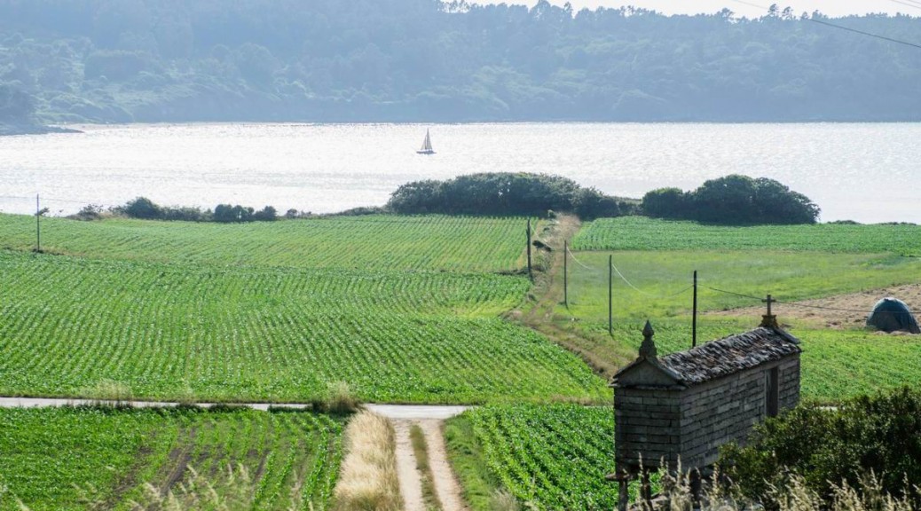
Going down towards the village, and before reaching the beach O Coído, we see one of the two dryers of conger eel that still exist in the area. The fishing of conger eel has been one of the main activities in Muxia for centuries. This type of fish is the reason why there are this kind of dryers which are also a testimony of how the inhabitants used to live. Today the few production goes to Calatayud, where it is considered to be a traditional product.

The Beach of O Coído, composed of rocks and sand became, with the first spills of fuel, the Zone 0 of the tragedy.

At this point, and after more than 30 kilometers and a 12-hour walking route (following the trasno´s pace), we finish the 6th stage of O Camiño dos Faros that took us from Camariñas to Muxía. The next stage will be the “king stage” (terminology used in cycling), which will take us to Nemiña walking through all the mounts and cliffs.

Sanctuary of Virxe da Barca (the virgin of the Boat)

At the end of this stage, we arrive at one of the key sites in this Camiño dos Faros: the Sanctuary of “ A Nosa Señora da Barca”, which is the end of the way pilgrims carry out who, after visiting the apostle, lead to this area of Finish Terrae to kneel down in front of the image of the Virgin and watch one of the most curious rocks full of legend.

We arrive at the Sancturary of “A Nosa Señora da Barca”, a building that was built to christen a place where some pagan cults were held by the ancient Celts. The first chapel was built in the 12th century and it got its importance as it became the final stage the pilgrims carried out, after visiting the apostle, led to this land Finis Terrae to kneel down in front of the image of the Virgin the legend says the Apostle Santiago encouraged to Christianize this land.

The temple we can see nowadays is the Baroque style and it was built at the beginning of the 18th century, thanks to the donation given by the Counts of Maceda, whose ashes are buried in one of the crypts inside the Sanctuary.

It has a Latin cross floor plan. Inside, the part that stands among the other ones, is the Baroque altar a piece of the sculptor Miguel de Romay. The twelve apostles are represented there standing around the alcove of the Virgin A Barca, who enjoys a great popular devotion.

The cult to the rocks is widespread in the area. The legend says that the Virgin arrived on a boat: the sail (the Rock of Abalar), the boat (the Rock of the Cadrís) and the rudder (the Rock of the Rudder) are the stone remains of the boat that are worth visiting.

The Rock of Abalar (“A Pedra de Abalar”) is a 9-meter long megalith of 30 centimeters thick. Its main feature is that it swings back (abala) when people stand over it, and the rock produces a hoarse sound. The tradition tells that this movement is caused when the people standing over it are free of sins.

Another legend says that this rock moves by itself to warn against the storms in the rough winter. In 1978, during one tough winter, the rock moved a bit and a part of it broke. Later, it was placed in the spot where it used to be and nowadays it is visited by thousands of “romeros” that go every year.

The Rock of Os Cadrís (“A Pedra dos Cadrís”) has the shape of a kidney (“cadrí” in Galician) and it is the rest of the boat of the Virgin. According the costume, the “romeros” have to walk under it 9 times to heal their rheumatic pains and the ones related to the kidney. Under this rock, the statute of the Virgin was found and taken to the Church. Somehow, it disappeared from the religious building and it appeared again under the stone. At the end, the sanctuary was built there.

Along the second week of September, around the sanctuary and in the village of Muxía one of the oldest “romerías”in Galicia takes place. It is also known that it is the most visited one: The Romería of “Nuestra Señora da Barca”.
 

There is no better place to finish this stage of O Camiño dos Faros: sitting on the Rock of Abalar at the sunset, enjoying it watching the kind of frightening sea of Muxía.  A Costa da Morte is a magic land and in moments similar to this one we realize that we live in a privileged area, where everything is a piece of art: the sea, the sun, the land, the seagulls… all of them come together to create a paradise on earth.

We have lived a beautiful stage that has taken us to this “Punta da Barca”

Route along Muxía

The beaches of Espiñeirido and A Cruz welcome us when we arrive in Muxía. We walk along them and we are willing to visit this peninsula full of history and natural beauty.


Along the promenade we see the statue of the poet Gonzalo López Abente, who was one of the poets that better described the beauty of this area. All along the walk which goes by small streets, we can enjoy the typical and small white houses that form the urban center.

We arrive at the fishing port, which is the main economic engine of the area. In some of the “tascas”  (typical Galician bars), that we can see in that area, we can enjoy the delicious local gastronomy before going up to the Sanctuary of “Nosa Señora da Barca” . If the weather conditions are good, we will try to get there to enjoy the sunset. We leave towards A Barca, but we will take a route different from the one people usually takes. O Camiño dos Faros goes up by taking the path that runs along the “Campanario de Santa María” to get the MountCorpiño, to later, descend directly to the point.

Santa María´s church was built in the 12th century. It has only one nave with a wooden gabled roof  and it is divided in three parts with transverse pointed arches. It still has its Romanesque door and some interesting pointed elements. The apse is communicated by a big triumphal arch.

The façade has pointed archivolts. There was a relief that represents the Virgin and Jesus. Nowadays, you can see it inside the church where we can also see  Rosario´s chapel, which was built in the 15th century. It is rectangular and it is covered with a ribbed vault.

The bell tower doesn´t belong to the main building and it was built over the same rock. We use its stairs to ascend to Mount Corpiño.


When we reach the summit, we have another viewpoint overlooking Muxía and this Costa da Morte that provides us with so many things.

When we reach the summit, we have another viewpoint overlooking Muxía and this Costa da Morte that provides us with so many things.

Chorente

Chorente is the last place we walk along before going down to Muxía by taking a perfectly marked that takes us to the beach Espiñeirido. It takes us only a few minutes to get there.

Monastery of Moraime

The Romanesque church of San Xiao de Moraime, built in the 12th century and declared a historical-artistic site, it is the remain of an ancient Benedictine monastery that is an essential element to understand the History of Muxía. The donations given by Alfonso V in 1119 helped to build it in the same place where there had been an old chapel that was destroyed firstly by the Normans and later by the Muslims.

It was built over an old Romanesque necropolis and it has a basilica ground plan with three naves and three apses. The apse that is in the middle is rectangular. The central nave is divided in five areas divided by semi-circular arches.


The decoration of the façade has some rose windows and small Romanesque windows that flank the main portal that adapts to the terrain relief, giving the impression that is not balanced. On the main portal we can point out the figures of the archivolts that surround the figure of the Salvador. We can say that they are kind of similar to the ones on the “Pórtico de la Gloria” (the Portal of the Glory) in Santiago de Compostela Cathedral.  By walking through the door of the southern wall, it was possible to enter the ancient monastery. On that door, we can see an image of the “Last Supper”.

Inside the northern wall, some ancient paintings that represent the seven deadly sins and the death were discovered. Near the church, the rectory house built in the 18th century, contributes to make of all these ancient buildings a very interesting group of ancient monuments.

In the excavations that have been carried out, some remains of an ancient fountain and of an ancient necropolis have been found. Only 1 kilometer away from there, we can see a L-shaped “hórreo” in Oruxo.

Os Muiños

Os Muíños is another typical village that is very well cared of in this Costa da Morte. We walk not only by “hórreos”, which are used to keep the harvest, but also by old stone houses looking for a turning point on the right that will take us close to the beach, one of the best ones in the municipality, by taking the route of the mills.

On our way to the mills, we see another of the wonders this Camiño dos Faros provides us with and we do love taking photos of,that is the scarecrow hanging from the trees, that gets surprised when it sees the Trasnos walking along this area.


The Route of the Mills of Río Negro is small and it is very well cared of. At the beginning of all the walk we see the Fonte da Tella (“the Fountain of the Tile”), a fountain with very fresh water and we will rest next to it. 50 meters up, the river descends forming a small waterfall on another unique spot.


Here we have to face again a problem we have dealt with in the previous kilometers. These boardwalks that are placed in shady places are full of moss and it is impossible to walk over them. However, we do it and although we do it very careful we don’t stop enjoying the beauty of this river Negro whose name matches the appearance of the place.

Along the walk we see several restored mills that in autumn, provide us with images like these ones …. As we have already said, O Camiños dos Faros, is a landscape in every step.


At the end of the route, in the mouth of the river, we descend some difficult steps to reach the beach of Os Muíños, one of the most visited in this municipality in summer. It is in a quiet bay and it has all the necessary services, which makes of this place the perfect spot to go with children.

As many of the beaches in this Costa da Morte, it is surrounded by some dunes with vegetation.

From this point, we have the option to visit the Monastery of Moraime and walk part of the St. Jame´s Way till Chorente. The other option, that is the one we follow in this Camiño dos Faros, is to go on by taking a path that is at the end of the beach and that will take us directly to Chorente by a steep hill.

Merexo

When we were discovering the route we were trying to link all the points along the coastline of Merexo. There is a fish farm of turbot called Prodemar belonging to the multinational Stolt Sea Farm. There are some plans to make it bigger, however, we the tTasnos wish they didn´t carry out these projects which can end up spoiling our environment. Let´s keep in good condition what nature provides us with, it is a treasure! Next to the fish farm, a “cetárea”, sells all kind of seafood.

Linking all the points along the coast of Merexo was not easy and, besides, the final route wouldn´t provide us with anything that special. So, we decided to design O Camiño dos Faros along the main street of the village, which implies saving some kilometers and this design will allow us to see a typical rural settlement as Merexo is, with its stone streets. Its inhabitants are really surprised when they see the Trasnos walk across their village.

At the end of the village we walk towards Os Muíños, it is about 1 kilometer and a half that coincides with O Camiño dos Faros.

Beach O Lago

The beach Lago is one of the most beautiful ones in A Costa da Morte, with a leafy pine grove that in summer months is considered to be the touristic attraction in this municipality. Apart from its beauty, the river Lago that flows calmly into the beach makes this place worthy visiting by families with children as there is a peaceful atmosphere that they will not find anywhere.

We will stop to have a bath and have a drink at the bars in the pine grove. At the beginning of the beach we see another lighthouse in our route that, although it is small and not very useful for the maritime traffic, marks the mouth of the river Grande. Its situation on a punta on the coast that brings the trasnos very special memories.

We descend from the lighthouse and we have a bath on that side of the beach but always being very careful. When you do such a long stage in summer, you have to get into the sea little by little wetting first your neck and wrists. If you don’t do so, the abrupt change of temperature may cause serious problems.

After the bath, we have a drink without spending long and we return to the Camiño.  There are 8 kilometers left to arrive in Muxía and 11 to finish the stage. At least 3 hours and a half following the trasnos´ pace. J We leave the beach walking along the bridge over the river Lago.

We still have all the final part of the stage left. This stretch will lead us close to Muxía by walking across quiet beaches and small rural villages. Berofe arriving to the campsite Lago, we turn on the right by taking a path, which is usually full of brambles, heading to Merexo.

Beach Leis

We leave the beach Area Grande ascending along some pine groves heading to Leis. When we reach the dirty track that descends till the beach we have two options. The easiest one is to turn left and go up the road that takes to the light house of the beach Lago.

But O Camiño dos Faros is not easy and it tries to run along the coastline, trying to take the right one going down till the beach Leis, where we have some panoramic views of the Ría. Curiously, Camariñas seems to be closer than Muxía, when it is absolutely the opposite.  An optical illusion that is not fun after walking 20 kilometers.

When going down to the beach Leis, its calm waters invite us to have a batch. It is an option, but we arrive first in Lago.

At the end of the beach, we have to cross among the rocks till we reach the lighthouse of the beach Lago. It is a kind of difficult walk and it is the only option. If you follow the prints left by the trasnos you will never have  to deal with a problem. But be very careful, and please, don´t try to reach the lighthouse by taking another route.

The stretch starts where the rocks are and it is true that it is not easy to walk among them. Through the rocks we get to a steep hill that is one of the most difficult in all O Camiño dos Faros. But, for the average walker it is possible to do it, although it is better to go with someone in order to help those ones who can find it more exhausting.

After walking for a while over these cliffs in Leis, we reach the beach Lago.


>