
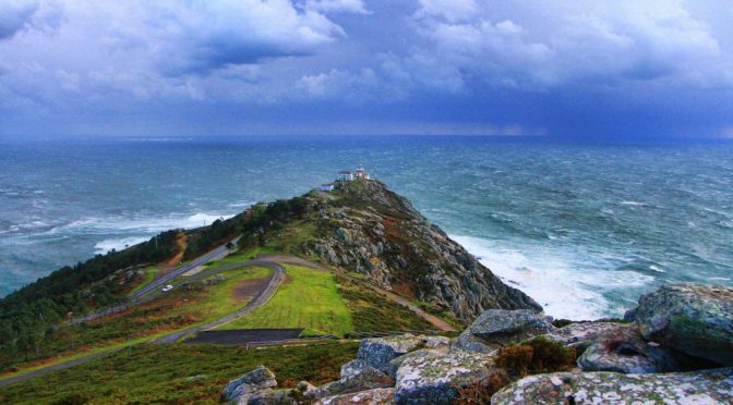
In this trail of unique natural diversity, this last section could not be missed. From Nemiña to Fisterra a succession of cliffs and beaches seem to be emerging with no way to stop them, one after another. In between, stories like the Cason or the visit to the unexcavated maritime fortress of Castromiñán. Hard stage but if you have arrived from Malpica, nothing will stop you before reaching the Fisterra lighthouse, the perfect culmination of this incredible adventure.
Download the track of the stage at Google Maps or Wikiloc


PLANNING SECTION 8 (it´s given in kilometers)
| POINT | KME | HOUR | DIF | PEL | AGU | TIME | KMM |
|---|---|---|---|---|---|---|---|
| SECTION 8: NEMIÑA – FISTERRA LIGHTHOUSE (27,0 Km) | 3 | 8h 45′ | 173.4 | ||||
| Subsection 8-1: Nemiña Beach – Lires Beach (6,5 Km) | 1 | 0 | 60′ | 173.4 | |||
| Start Nemiña Beach | 0 | 10:00 | 173.4 | ||||
| Panoramic path of the Nemiña Dunes | 0.8 | 174.2 | |||||
| Frixe Road | 1.9 | 1 | 175.3 | ||||
| Crossing Vaosilveiro Forest | 2.8 | 10:45 | 176.2 | ||||
| Vaosilveiro | 4.2 | 177.6 | |||||
| Vaosilveiro Bridge | 4.3 | 11:00 | 177.7 | ||||
| Lires | 4.7 | 11:10 | BAR | 178.1 | |||
| Church of San Estevo of Lires | 5 | 178.4 | |||||
| Lires Bridge | 5 | 178.4 | |||||
| Estuary of Lires | 5 | 11:15 | 1 | 178.4 | |||
| Lires Beach | 6.5 | 11:30 | 179.9 | ||||
| Turn left path exit of Lires | 6.5 | 11:30 | 2 | 179.9 | |||
| Subsection 8-2: Lires Beach – Rostro Beach (4,0 Km) | 2 | 2 | 90′ | 179.9 | |||
| Soleiros spring water | 7 | FUE | 180.4 | ||||
| Area Pequena Beach | 7 | 180.4 | |||||
| Area Grande Beach | 7.3 | 2 | 180.7 | ||||
| Turn right Punta da Lagoa | 8 | 181.4 | |||||
| Punta de Lagoa | 8.2 | 12:15 | 1 | 1 | 181.6 | ||
| Vela Mount (emergency scape) | 8.7 | 182.1 | |||||
| Turn right descent to Mexadoira | 9.5 | 1 | 182.9 | ||||
| Punta Mixirica | 9.6 | 183.0 | |||||
| Cliffs of Mexadoira | 9.6 | 12:45 | 2 | 3 | 183.0 | ||
| A Mexadoira | 9.9 | 183.3 | |||||
| Descent to Rostro Beach | 10.2 | 13:00 | 183.6 | ||||
| Rostro Beach | 10.5 | 183.9 | |||||
| Subsection 8-3: Rostro Beach – Arnela Beach (5,8 Km) | 2 | 2 | 75′ | 183.9 | |||
| Rostro Beach South (30′ picnic) | 12.7 | 13:45 | 30′ | 186.1 | |||
| Cliffs of Punta do Rostro | 13.3 | 14:30 | 2 | 3 | 186.7 | ||
| Castro of Castromiñán | 14.5 | 14:50 | 2 | 187.9 | |||
| Cliffs of Gavioteiro | 14.6 | 15:00 | 2 | 188.0 | |||
| Cliffs of Arnela | 14.6 | 1 | 2 | 188.0 | |||
| Arnela Beach | 16.3 | 15:30 | 189.7 | ||||
| Subsection 8-4: Arnela Beach – Cape of Nave (3,1 Km) | 3 | 2 | 75’+15′ | 189.7 | |||
| Punta Robaleira (ascent 2,3 Km, 11,4%) | 17 | 190.4 | |||||
| Punta Longa | 17.8 | 191.2 | |||||
| Punta Longa spring water | 17.8 | FUE | 191.2 | ||||
| Croa stream (turn left exit of path) | 18.6 | 192.0 | |||||
| Cape of Nave (15′ stop) | 19.4 | 16:45 | 15′ | 192.8 | |||
| Subsection 8-5: Cape of Nave – A Insua (3,9 Km) | 1 | 1 | 45’+15′ | 192.8 | |||
| Corticeiras | 20.7 | 194.1 | |||||
| Mar de Fora Beach | 21.9 | 17:30 | 2 | 195.3 | |||
| A Insua (Spring & Bar) (15′ stop) | 23.3 | 17:45 | BAR | 15′ | 196.7 | ||
| Subsection 8-6: A Insua – Fisterra Lighthouse (3,7 Km) | 2 | 0 | 45′ | 196.7 | |||
| Ancient path of Insua | 23.4 | 18:00 | 196.8 | ||||
| Path Cabo Mount | 23.8 | 197.2 | |||||
| Punta dos Oídos – Ascent to Facho Mount (650 m, 18%) | 24.9 | 198.3 | |||||
| Facho Mount | 25.6 | 18:45 | 199.0 | ||||
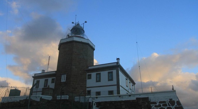
| Fisterra Lighthouse | 26.9 | 19:00 | 200.3 | ||||
| Final point Camiño dos Faros | 26.9 | 200.3 | |||||
KME – Kilometers of the section
TIME – The schedule that appears in the documentation is the perfect time to walk the path, taking the section calmly, enjoying the landscapes and making the necessary stops. The departure is always recommended at 10:00 A.M..
PEL (Danger) – Danger of the section (0: Nil; 1: Low; 2: Medium; 3: High)
DIF (Difficulty) – Difficulty of the section (0: Nil; 1: Low; 2: Medium; 3: High)
AGU (Water) – Presence of Water (FUE: Source; BAR: Bar; REG: Stream)
TIE (Time) – Time of walking or stop
KMM – Total kilometers from Malpica
DESCRIPTION SECTION 8
The last stage of this Camiño dos Faros is quite long, that´s why we suggest starting it kind of early.
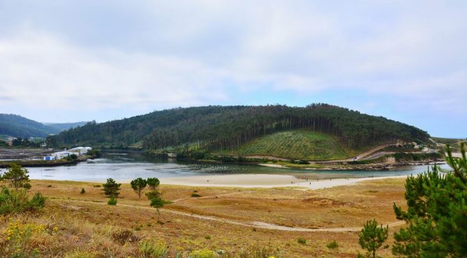
The stage starts on the beach Nemiña, walking along all then sand till we reach to the mouth of the estuary of Lires. On the other side, the beach of Lires the one we will reach following our Camiño dos Faros. We have to options to get to it: Walk across or border it. O Camiño dos Faros takes always the worst route, that´s why it heads up the river to walk over the bridge of Vaosilveiro and reach, by walking across the village of Lires, the beach with the same name after walking 3 kilometers. We can save all this walk by walking across the ría, but this is only possible a couple of hours every summer. During the raining season it is impossible as a channel is formed.
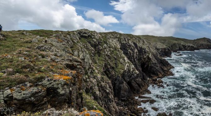
From this point, the stages starts being demanding all along the coast of Lires with a steep ascent leading to the awesome cliffs of Point Besugueira and of Mexadoira, that we will walk across one of these amazing landscapes O Camiño dos Faros provides us with.
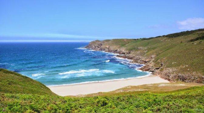
The next point in this route is the beach of Rostro (“face”), another universe of feelings. We will walk across the beach listening the continuous noise the waves make overwhelming everything surrounds us. At the end of the beach, we will ascend by taking a small path till the Point of Rostro, where we can admire some amazing views and it is a very good place to have something to eat and drink.
As soon as we leave behind the beach of Rostro and after turning over ourselves we see another unique landscape of this Camiño dos Faros. The cliffs formed by the Point of Rostro and the Point of the Castelo that we will go across walking along its highest parts, which will make us remember that the Casón hit against them making its inhabitants leave the area as it had never happened before.
There, in Point Castelo, we visit the remains of the Castro de Castromiñán although we can only see its exterior walls and from this point we can see the end of this stage: The cape of the Nave. In order to reach it, we have to turn off a bit towards the inland and go across the villages of Castromiñán and Denle before reaching the beach of the Arnela and start the ascent.
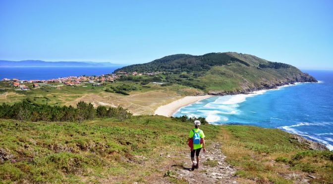
O Camiño dos Faros continues in crescendo and this stretch of Cape of the Nave is one of the most amazing ones. From the track that borders the beach of Arnela, we start the ascent that will take us to the antennas of Cape of the Nave by taking a track among the rocks with the highest cliffs in our route. When reaching the end, we take a rest we deserve before facing the end: the last descend, the last beach, the last mount before getting to the Lighthouse of Fisterra, our goal.
From the cape of the Nave and walking down a very steep descent we reach the beach of Mar de Fora and from the picnic area we ascend looking for the Camiño da Insua, that will take as close to the Mount Facho, where the last ascent is the last great and fascinating effort.
Ascending without stopping, we reach to the Western part of the Cape, and from that point we start the last slope which is actually very steep and very stony before admiring the first views of the lighthouse Fisterra, the one we reach by taking a route that is completely different from the others: O Camiño dos Faros.